1280 Royalties LLC


Our Story
At 1280 Royalties, our journey began with a vision of providing mineral owners with accessibility to options that allow them to capitalize on the value of their mineral rights. Drawing from decades of collective experience, our seasoned professionals recognized the need for a one-on-one approach to working with mineral owners in an industry often shrouded in complexity.
Why Choose 1280 Royalties

Trustworthiness
We have a proven track record of purchasing mineral rights and working with mineral owners to achieve their goals in a sale.

Industry Knowledge
Our team is comprised of industry experts who understand the intricacies of the oil and gas business.

Efficiency
We're committed to making the selling process as efficient as possible so you can access the funds you need quickly.
Ready to take the next step in monetizing the value of your oil and gas mineral rights? Contact us today to begin the seamless process of selling your minerals.
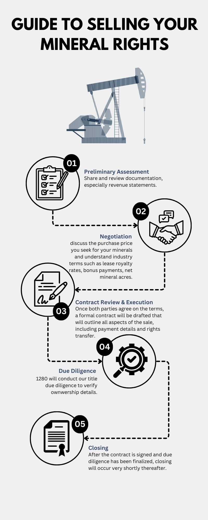
How It Works
- Preliminary Assessment
- Negotiation Process
- Due Diligence
- Contract Drafting and Review
- Closing

Ready to unlock the true potential of your oil and gas mineral rights?
Don't miss out on this opportunity to maximize the value of your mineral rights. Take the first step towards bringing value forward today. Click 'Get Started' now and discover the potential waiting beneath the surface!
Blog
Hidden Wealth: Selling Mineral Rights in Campbell County, WY
Unveiling Opportunity: Selling Mineral Rights in McKenzie County, ND
Maximizing Your Land’s Potential: Selling Mineral Rights in North Dakota to 1280 Royalties
Unlocking Wealth: Selling Mineral Rights in Williams County, North Dakota
Balancing Prosperity and Preservation: Wyoming’s Oil and Gas Triumphs and Environmental Stewardship
Should You Sell Your Mineral Rights in North Dakota? Exploring the Pros and Cons
Navigating Regulatory Changes: Why Selling Minerals in Colorado Makes Sense
Sell Mineral Rights in the Bakken
Guide to Selling Your Oil and Gas Mineral Rights with 1280 Royalties
Mineral Rigths in Wyoming – Sell Now
What’s The Value Of My Mineral Rights in North Dakota?
Unveiling the Bakken Shale: A Geological Marvel
Get in Touch
- 303-770-6040
- [email protected]
-
1280 Royalties, LLC
5460 S. Quebec St., Suite 335
Greenwood Village, CO 80111
Testimonials
Allan W.
Snohomish, WA
The process of our sale flowed seamlessly and quickly. My point of contact, Mallory Quay, was professional and most efficient with communication and process. She's very knowledgeable and customer oriented. my experience with 1280 Royalties is the best I've had with a mineral acquisition company.
Camille H.
Gardnerville, NV
Mallory was great about getting back to me about any questions that I had and was very personable, and was the reason I chose 1280 Royalties.
Stephen B.
Whittier, CA
I would like to thank Mallory for being so kind and polite. She made the process easy and got everything done in days.
